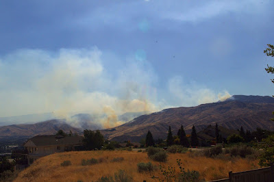
All photo's on this page by Vladimir I. Steblina, Forest Service.
Friday, September 21, 2012
Sunday, September 16, 2012
Peavine Fire Photos
usbackroads--Peavine Fire Photos
photo courtesy Vladimir I. Steblina, Forest Service.
photo courtesy Vladimir I. Steblina, Forest Service.
Poison Fire Photos
usbackroads-Poison Fire Photos
photo courtesy Vladimir I. Steblina, Forest Service.
photo courtesy Vladimir I. Steblina, Forest Service.
photo courtesy Vladimir I. Steblina, Forest Service.
Confluence State Park Fire Camp Photos
usbackroads- Confluence State Park Fire Camp Photos
photo courtesy Vladimir I. Steblina, Forest Service.
photo courtesy Vladimir I. Steblina, Forest Service.
photo courtesy Vladimir I. Steblina, Forest Service.
First Creek Photos
photo courtesy Vladimir I. Steblina, Forest Service.
photo courtesy Vladimir I. Steblina, Forest Service.
photo courtesy Vladimir I. Steblina, Forest Service.
photo courtesy Vladimir I. Steblina, Forest Service.
photo courtesy Vladimir I. Steblina, Forest Service.
Monday, September 10, 2012
Devil's Gulch Fires--September 10th, 2012
Devil's Gulch Fires--September 10th, 2012
Update: Photo's taken from Inspiration Point just east of Camas Meadows Natural Area Preserve. They were taken at noon, just before high winds from the west hit the area. Fire behavior should be pushing the fire and smoke east towards Wenatchee. Winds are expected to lessen tomorrow and the fire will end up being slope driven rather than wind driven. The following is a pano series.
Looking into the Devil's Gulch Area I counted 14 separate fires from the viewpoint. 10 of those fires were greater than 5 acres in size judging from the smoke.
Sunday, September 9, 2012
Wenatchee Fires--September 9th, 2012
Wenatchee Fires--September 9th, 2012
As always click on photo to enlarge.
Time: 0850
Time: 0912
Time: 1052
Time: 1052, Horse Lake Mountain
Time: 1100
Time: 1205
Time: 1231
Time: 1332
Time: 1442
Time: 1205
Time: 1332
Time: 1442
1442....Update: The fire has continues to creep down the ridge on the Wenatchee River side. Since the main branch of the fire is down in canyon and not visible it is hard to determine how much the fire has grown. However, compared to this morning it looks like the entire ridge has been burned and is slowly creeping down the ridge. There is another fire in Poison Creek just east of Camas Meadows and north of Cashmere. It is starting to put smoke up in the air. So it looks like a smokey end to summer in the Wenatchee Valley.
Time: 1845
1845......Update. The lower end of the fire is in fairly good shape. Fire is at about 800 acres, with 115 firefighters and one helicopter. The helicopter did great work and the lower end of the fire where the homes are located is in fairly good shape. It looks like that little spot fire in the timber is getting more active and will merge into the Canyons Fire. There are many fires in Devil's Gulch and Poison Canyon next to Camas Meadows. Up by Manson there is another large fire. Tomorrow's adventures??
Time: 1945
Subscribe to:
Comments (Atom)


