Monday, August 30, 2010

Blog Summary--Backroad Destinations


Blog Summary-Backroad Destinations

It is time to list all the backroad destinations in one place.  Fall is coming with its colors.  Check out these places with fall colors, before they become simply white in December.  Click on description to go there!

Blackfoot-Clearwater Wildlife Management Area, Seeley Lake, Montana

Chewuch River, Winthrop, Washington

Table Mountain, Ellensburg, Washington

Highway 20, Twisp, Washington

30 Mile Fire Memorial, Chewuch River, Washington

Chiwawa River, Plain, Washington

Icicle Creek, Leavenworth, Washington

Sierra Buttes, Sierra City, California

Wallace, Silver Valley, Idaho

North Fork Coeur d'Alene river, Shoshone County, Idaho

Lower Coeur d'Alene River, Idaho

Texas Rapids, Snake River, Starbuck, Washington

Here is the link to the previous blog summary on destinations posted this spring.

Backroads Destination Summary for Spring

With the color weather and responsibilities of this summer behind us we are ready to hit the road again.  More unique destinations coming this fall.

Friday, August 27, 2010

The Art of Seeing in the Outdoors

One of the characteristics that separates the outdoors person from the city person is the ability to see in the outdoors.  In previous chapters I talk about interpreting ecological landscapes. It is the ability to see what is different in a landscape that will make your outdoor experience richer and meaningful.  Ok, look at the picture above.  What do you see?

First, what signs of man do you see?  Nature abhors straight lines.  Mankind likes straight lines.  So any straight line is likely to be a sign of man's activities.  See the straight lines on the hill in the middleground and in the background?  Those are roads.  Look carefully at the meadow.  Do you see the two straight lines?  Those were old fence lines from the period of time the meadow was farmed and grazed and now grown in with shrubs.   You know this meadow might look natural, but it has man's imprint. 

There are very few books about seeing in the outdoors.  I have only found one, "The Outdoor Observer:  How to See, Hear and Interpret in the Natural World" by Charles Elliott.  I was stunned to find it in a used bookstore.  I am even more surprised that another book on the subject has not been written.

There is a reason for the words "earth colors".  Most landscapes are blue, green, and brown.  This is why "Forest Service flowers" tend to be shocking pink, orange, and yellow.  Now as a Forester, I was always looking for signs of man's activities such as property lines, roads, and other evidence of "prior" foresters.
So early on, I learned to look for straight lines and "forest service flowers".

However, natural landscapes also offer clues.  When you look at a landscape try to see what is different.  In many cases, it will be an elk or a deer at a distance.  It just looks different.  Like those old comics that asked you to identify what does not belong in the picture.

Look at this picture.  What is different?


Next time, I will not put it in the middle of the picture.  That shrub is much bigger than the other shrubs in the meadow.  Lets look at it from the other side.

Well, that explains it.  There is a spring in the middle of all that vegetation. So while other shrubs had stopped growing due to drought, this one just kept growing.

I did find some pipe around, so somebody knew there was a spring here in the past.  But the elk have also found the spring and created this elk wallow.  Wow, if the local Department of Ecology found out about this they would probably write the elk a ticket.

Bugaboo on the other hand thinks the elk wallow is just fine.  Now Bugaboo can find water by smell and using his other skills.

You, however, need to learn how to interpret the landscape and see the world with new eyes.  It is not hard.  In this case, it was simply the case of looking to see what is different and then finding out why?


So as I wandered around the meadow taking these pictures, I noticed something about this aspen grove.  Can you tell what it is?

There are what foresters call two age classses.  Notice that there are two sizes of aspens.  So what happened sometime ago to allow the second set of aspens to start growing?  Was it the end of domestic grazing on the meadow?  A drop in the population of the elk herd?  Did that fence post in the foreground have anything to do with it?  I am not sure.  One of these days I will take out my increment borer and core the trees to find out how old they are.  That will give one clue.

Seeing in the outdoors, coupled with the question: Why?.  That will help you discover the wonders of nature and the wild places missed by so many visitors.

Tuesday, August 24, 2010

The Toughest Thing about Retirement

Backroads Information-The Toughest Thing about Retirement

Prior to retirement I kept asking retired folks about retirement.  There were the usual questions about travel and finances.  However, I asked one couple "What is the toughest thing about retirement".  Their answer surprised me and gave me pause.  They said "You lose on average a friend a year and all you are left is your memory of them".


This summer is my fourth in retirement and yesterday I lost a close friend.

Brad was the most unlikely friend.  He did NOT drink, smoke, swear, hike, hunt, fish, argue about politics or the weather.  He did not listen to classic music like Hank Williams or that middle-ages stuff from Europe.  He was without a doubt the worst driver I ever had to follow on a Forest Service road and he was allergic to dogs.  

Back in the early 1990's the Wenatchee World did a feature story on our little astronomy group in town.  Brad read the article and commented to his wife that he was always interested in astronomy, but had never done anything about it.  His wife encourage him to call us.

Now we got four or five calls from people curious about astronomy as a hobby including one from Brad.  My friend that spoke to Brad gave me a call about Brad's interest in astronomy.  I said "Great, but lots of people show interest in astronomy and very few follow through because it is a difficult hobby".   Frank said "but you don't understand, he is a machinist".  Now for an amateur astronomer to find a machinist that is interested in astronomy is the equivalent of going out with a Playmate when your 17 years of age.

So there were definitely ulterior motives on our parts.  Which is understandable since Frank and I are "practicing Christians".  That is we need lots of practice.  Frank went through the Marine Corps as a helicopter pilot and flew a fire helicopter for LA County fire department.  I went to school at Berkeley with the California National Guard and we both left campus at the same time.  You could see why we had become "practicing Christians". 

Brad on the other hand was simply a Christian.  More on that later.

Brad came over to Franks house where he was shown Frank's 10inch Newtonian telescope on a German Equatorial Mount.  Frank showed Brad how the telescope worked and complained about the tangent drive on the declination axis.  Brad said I can fix that.  Now when people say that it is usually to show how smart they are without having to "actually" fix it.  Two days later he showed up at Frank's house with a completed tangent arm that actually worked better.

Later in the month we went up to a dark sky site outside of town with our group.  Brad barely knew the constellations and was interested in looking through the telescopes.  I showed him how to operate the computer that pointed my telescope and settled into my LaFuma with a beer.  I called out the ID numbers for celestial objects that Brad then punched into the computer, moved the telescope and we started talking a astronomy, life, and other cosmic topics.  He looking at the stars and me drinking my beer.

He was hooked and Frank and I had a machinist for a friend.

Now as "practicing Christians" Frank and I did tease people that did not walk the talk.  We started out teasing Brad but quickly learned that he was the real thing.  There was not a mean bone in his body.  We never heard a discouraging word.  He did not boast, lie, cheat or do any of those other things that cause humans to fall short.

We stopped teasing him fairly quickly.  And soon his good nature and his willingness to help anybody and everybody without any expectations soon started changing us.  I ended up being a much better person for having known Brad and as a result needed "less practice".   I guess I finally understood what my mother meant by your friends changing you though I suspect she never thought I would find one that would change me for the better.

Now God gave Brad a gift that let him fix and build things.  From piles of aluminum, wood, and glass came works of art that were functioning telescopes.  Even the simple ones have the elegance and style of good design.   He completed a 24 1/2 inch telescope that was 10 feet high about the same time he was diagnosed with brain cancer.

A couple of weeks after his brain surgery he called and asked for my help for a couple of hours one morning.  We went over to a neighbors yard and fixed their fence.  He needed my help to hold the fence boards and drive a few screws.  He stayed in character throughout his difficult trial with brain cancer.

I am going to miss him.  I am going to miss observing the stars late at night with him.  After a couple of years he knew the night sky better than I did, but he never told me that.   I have one of this telescopes and the memories of a friendship and I now know the "toughest thing about retirement".

As life goes on and I face those simple choices and decisions in everyday life I am going to have to remember to think "What would Brad do?".   Hopefully, I will need "less practice" having known Brad.


Here I am helping Brad build my observatory.  Brad on the left and me on the right.

The picture at the top of the blog is the observatory after a light Cascade snowfall.  Yes, Virgina there is an observatory under all that snow.  Next winter, Arizona.

Here is an article in the Wenatchee World on Brad.

Monday, August 23, 2010

Texas Rapids, Snake River , Starbuck, Washington


Yes, Virginia there is a Starbuck, Washington.  But more on that at the end of this blog.

The Snake River in Washington is the site of the infamous Snake River Dams.  It is also home to some of the best camping and fishing in Washington state.  The river provides fishing for steelhead, salmon, sturgeon, both smallmouth and largemouth bass, catfish, and a host of other species.  You can even fish for money by catching the northern pike minnow.  Northern Pike Minnow Fishing Reward Program.

The Army Corp of Engineers manages the recreation facilities along the river.   There are lots of campgrounds and boat launches.  Camping is allowed at most boat launches and is free.  The campgrounds Lyon Ferry and Central Ferry are managed by concessionaires and are expensive plus the Golden and Inter-agency passes are not accepted.  My recommendation is to skip the campgrounds until the management settles down.  Right now, most close early in September.

The best time to visit is September and early October prior to hunting season.  The area is very popular with hunters so do not forget to bring your hunter orange!

Four bars cell service with Verizon at Texas Rapids.

Here are the google earth coordinates for Texas Rapids.  46 33 45.59 N 118 06 01.24 W.  You can camp on the breakwater, but first be sure you can back up your trailer in a straight line!   There are additional camping areas up and down the river.  Here is the link to the Army Corp of Engineers web site: Walla Walla COE Recreation Web Site.  There is potable drinking water at Little Goose Dam along the fishing wall.

For lunch or dinner I would go here:  Patit Creek Restaurant.  Be sure to call ahead for reservations.   This area is only a short drive from the Walla Walla wine country.  We will have additional posting in the near future on all the activities in this area. 

The Snake River Country of eastern Washington is in the middle of that all important "somewhere".

Last April 1st I saw the following article in the local paper.

Starbucks Loses Trademark Case

(Yakima) Starbuck Corporation has been very aggressive about trademark infringement suing many small business owners throughout the world.  Today it found itself on the losing end of a trademark lawsuit.

In a stunning decision in the eastern Washington District Federal court Senior District Judge Quackenbush ruled that the company formerly known as  Starbucks must stop using the name Starbucks as it infringes on the community of Starbuck, Washington.  In a statement the mayor of Starbuck, Olivia Newton stated that they have tried for years to get the large corporation to change their name.   "We are a community of wheat farmers, cowboys and retired folks that spend their time fishing.  When the corporation formerly known as Starbucks started using our name we started having all these yuppie people showing up looking for the FIRST Starbucks coffee bar, asking about wi-fi and generally making a nuisance of themselves.  We want our community back.  We are sorry it came to a lawsuit, but the corporation formerly known as Startbucks just refused to listen".

The corporation formerly known as Starbucks stated that their name came from the novel Moby Dick and was not picked from a Washington State Highway Map.  Judge Quackenbush did not accept that argument and stated that the town of Starbuck has been harmed by the corporation formerly known as Starbucks using their name.  He gave the corporation formerly known as Starbucks one year to change their name or face contempt of court.

In related news, the Board of Directors for the corporation formerly known as Starbucks held a closed door meeting in Port Townsend today.  Ms. Adna a waitress said "They were pretty glum coming into the meeting this morning.  However, as they left this afternoon they were high fiving and laughing.  When I went to clean up the meeting room there were Washington State Highway maps everywhere and on every map the town of 
Humptulips was circled".

There is no expresso in Starbuck.  The local cafe does serve coffee.....black.

Friday, August 20, 2010

In the Middle of Somewhere.....

Backroads Product-Songs for the Road

On one of the hiking forums a woman hiker was commenting on her need to get out of Seattle and "get to the middle of somewhere".  Now if your reading this blog you know the importance to get to the "middle of somewhere".  Most of society tends to refer to these area's as the "middle of nowhere", but we know better.

This posting is about songwriters that write songs about the "middle of somewhere".  Generally, these will have a western bent.  The "middle of somewhere" is also a great place to reflect on life and the times of our lives.

You already know Ian Tyson from the sixties folk group Ian and Sylvia.  You might even know that he wrote songs like "Four Strong Winds" and "Someday Soon".  Even though I kept my Ian and Sylvia albums I lost track of the fact that Ian was still recording.  This is  his best album with lots of great songs.

If you travel the west you will recognize the places.  If you lived and worked in the west years ago you will recognize songs like "Summer Wages" and "Navajo Rug".

These are western songs.  Not country, but western.  Great CD to listen to and I can guarantee that if will stay in the CD player for months.   There is road music that moves the miles and there is road music that moves the memory.  This is the latter.


Heidi Muller is a folk singer from Seattle.  But many of her songs are about the rural areas of eastern Washington.   The album "Matters of the Heart" is good, but my preference is for this album:  Cassiopeia.  I particularly like "Long Way to Another Friend", "Palouse Lullaby", and "Cassiopeia" which combines the constellations with backroads of eastern Washington.

These are great songs, with simple instrumentation.  If you like folk at all, you will like these albums.  One of the great things about digital recordings is acoustic instruments sound great on them.  Clean sound that makes it seem like your right there if you have a good speaker system.

If you have ever been in the Palouse country you will love this album.

This CD Kelly L.Riley "My Kind of Road" is about the backroads of the American west.  It has become a favorite of all my Forest Service friends.  On this CD you will find references to the John Day River and Summer Lake in Oregon, the Payette River in Idaho, and other places well known to those of us that travel the backroads.

The song " Tequila Tonight" has the great line "Tears and Tequila flow like a river tonight."  Great songs about lost loves and the landscape of the west that seems to encourage those lost loves.  All the songs were written by her.

There is also her voice.  Somewhere in the neighborhood of Pasty Cline and K.D. Lang.  As a friend said, "What a voice.....what does she look like?".  Hmm, maybe it is attitudes like that lead to those lost love songs!


When I travel I ride with Bob Wills, Merle, and the Dead.  But these three CD's get played as often as those by the more famous performers.  Give them a try.  You won't be disappointed.

There are lots of great singers and performers out of the backroads.  These are three I have found that you might have missed.

Wednesday, August 18, 2010

Living on the Edge


Backroads Information-Living on the Edge

I loved my Forestry education.  The required classes in the sciences, sociology, and economics  gave an overview of this world that few educations can match.  It was a 20th century version of the old Liberal Arts and Sciences degrees from the 15th century.

I remember a Forestry professor talking about how professions define themselves by creating a unique vocabulary both to include "the chosen" and exclude the " rabble".  He lamented this trend, but insisted that we learned the lingo.  He also insisted that we learn to observe, think, and draw inferences from what we saw in society and the landscape.

I remember in sociology that the "groups" on the edge of society is where change comes about.  In economics it was the marginal cost and revenue curves that were important.  And in wildlife ecology classes the quote I remember is, "Everything happens on the edge". 

Look at the picture on top of this posting.  Notice the edge between the meadow and the aspen groves.  There is an edge between the conifer forest on the meadow in the background.  In the conifer forest there are clumpings of larch among the other conifers.  But did you notice the "edge" in the meadow?  Did you notice the change in the meadow grasses?


Well, these ladies pay attention to the edge and the changes in vegetation.  So much of science is learning the vocabulary, but the important stuff is learning to see.  I remember my first ecology teacher taking us out on field trips to look at landscapes.  He did not identify the trees or grasses by name, but asked us to "see" what was occurring in the landscape and how it was before, now and how it will change in the future.

So what does this have to do with boondocking?  Well, find landscapes with "edge".  These will be the most interesting places to stay.  I have walked  through miles and miles of pine, coast and sierra redwood forests in my jobs.  The interesting stuff was always on the edge of those forests.  The federal agencies that manage public land also know this.  This is why you will tend to find camping restrictions on the "edge" of ecosystems.  There will be more and more restrictions in these areas, while facilities and campers will be moved to interior portions of ecosystems rather than the edge.


One of the most important "edges" is riparian areas.  These will be the "rare" campsites in the future.  Enjoy them now and minimize your impact while staying in these areas.

One of my favorite books is this one.  It is one of the few books that wraps sociology, economics, and ecology and shows how it affects everything.  Without giving away the ending, find out how a society on the edge of "failure" managed in a relatively short time to take over the world!  We tend to forget that in the middle ages European society was on the "edge" and an inconsequential part of the world.

I really enjoyed  the book since it shows how ecology affects society and how society changes the natural ecosystems, in turn. 

The important thing is to not learn the names of the trees and grasses, or birds but learn to see and correctly interpret what you see.  Try it.  Next time you are visiting a natural history interpretive trail.  Walk the trail first and see what you see.  Then walk it again and see what you got right.

Sunday, August 15, 2010

Lower Coeur d'Alene River, Idaho


Backroad Destination-Lower Coeur d'Alene River, Idaho

I accepted a job with the Forest Service in Coeur d'Alene in March 1978.   Since I was working for the Park Service at Lake Mead and needed to complete my job there  I set my reporting date as late April.  I dreamed about spending my weekends wandering the mountains of Idaho.  It turns out I bought a canoe and spent much of my free time canoeing and exploring the lakes of the lower Coeur d'Alene River.  Of course, the Forest Service was paying me to wander among the peaks and lakes of the northern Rockies during weekdays.  So I guess I needed a different environment on my days off.


The lower Coeur d'Alene River area is important in my life in other ways.  Recently, my wife was musing about what happened to that young romantic Forester she met on our first date.  A canoe trip, complete with picnic lunch with a red checkered table cloth for seating and of course the mandatory bottle of wine with two wine glasses. 

Romantic?  The first date was a canoe trip through a swamp to an isolated island.  The red checkered table cloths came from the commercial laundry where my mother worked.  The wine.  Well, you can take the kid out of California but he will probably take some wine with him and always drink it out of wine glass unless he is backpacking.  I do have to admit I was impressed that she just said yes to a canoe trip through a swamp for a first date.  We launched at the Killarney boat ramp and headed west to our island and as they say the rest is history.

The boat ramp is now also a small campground that can take large rigs with campsites both the water edge and mountain side.  


If you like bird watching or waterfowl hunting, kayaking, canoeing, fishing for pike or bass, gathering wild rice, or riding a bicycle this is the place for you.  The Trail of the Coeur d'Alenes  and has been covered under my previous post on Wallace, Idaho.  Trail of the Coeur d'Alenes.  Links are at the end of the post.

The one thing the area lacks in is campgrounds and camping areas.  There is the campground at Killarney Lake.  The campground fee is only eight dollars includes water and garbage services.  Other possible campgrounds are Heyburn State Park: Heyburn State Park.  It is just outside of the lower Coeur d'Alene River, but does provide easy access to the bicycle trail.  This might be a good choice if bicycling is your primary interest.   There is also a private campground next to Old Mission State Park, but we have not stayed there just driven past.  You can also stay at the Forest Service campgrounds on the North Fork of the Coeur d' Alene River.

Up from the river bottoms it is National Forest land and you can disperse camp there, but you might have to search a bit for an ungated road.  Contact the Forest Service for additional information.  This is what you need to disperse camp in north Idaho.  Click on photo.


Do not forget to visit Catado or Old Mission State Park.  There is not much "old" stuff in Idaho.  This is worth the visit:  Old Mission State Park

The trailheads for the bicycle trail are located up and down the  trail, but no camping is allowed at the trailhead.  There is a Forest Service boat launch at Rainy Hill that would make an excellent boondock, but the website states no camping.  Here are some of the trailhead signs for the bicycle trail and trail.

 
That's the good news.  The trail is actually a superfund site.  It is the old railroad grade through the valley.  As part of the clean-up the proposal was to pave (cap) the railbed and turn it into a public recreation site.  Here is the "official" sign at Killarney Lake.  It was not there in 1978.

This is a unique part of Idaho.  It was one of favorite haunts when I lived in Coeur d'Alene.  It probably is not for everyone, but if your first date was a canoe trip in a swamp you will probably like it.

Friday, August 13, 2010

Over Garments


 Alpine Lakes Wilderness in July.

Finding good field clothing is difficult.  Lots are made for backpacking, where light weight is as important as strength and functionality.  But in most cases, you want well designed tough clothes.  Of all the manufacturers, my favorite is Columbia Sportswear.  Most of their clothes are well designed for the outdoors and wear well.  Cabela's also has good outdoor clothes though their colors tend to run toward camo and orange.

The key to staying warm and dry in the outdoors is really the under garments.  Over garments, however, are also important.  But always make sure you have a strong foundation and layer for ultimate comfort.

Pants are also important.  Well, most foresters wear jeans.  However, jeans are meant for the office or riding horses.  They are really not that comfortable jumping over logs in the woods or scampering up hillsides in wet weather.  So, on those tough jobs in foul weather I reach for wool pants.  The best place to buy wool pants is at the local Goodwill or Salvation Army Store.  I always get a pair of suspenders to go with them and then cut the cuffs from the legs.  Warm when wet, with suspenders to hold them up, lightweight wool pants are just the ticket for the outdoors.

Yes, I did say that you wear jeans to the office and dress wool pants into the field.  I did wear a three piece suit on a few occasions when the setting demanded it, however, thank God it was functional outdoor clothes most of the time.   Those fire fighting nomex pants are comfortable in the field, but horrible in wet weather and at $129 a pair a bit expensive.

Fleece and more fleece.  Silk underwear, fleece pants, fleece gloves, fleece hat, merino wool top, fleece vest, and then a down jacket to top it all off.   This photos is from Mid-July in the Alpine Lakes Wilderness in north-central Washington.  You can see these mountains from my house in Wenatchee, where it was 100 degrees that day,  just 30 miles away and 6000 feet lower.

Shirts are a little tougher.  In most cases, I just wear long sleeve t-shirts.  You can always push up the sleeves if you're too hot in the woods.  The long sleeves protect you from thorns, branches and bugs.  Generally, I stay away from cotton unless I know it is going to be nice weather.  Having gotten caught a couple of times in a thundershower wearing cotton, it was just miserable.

Fleece is the miracle outdoor fabric.  I replaced ALL my vests and lightweight jackets with fleece.  Again quality does vary, but less than with other fabrics.  Make sure the weight of the fleece, matches your intended temperatures.  I prefer 200 weight fleece.

I threw out all my cotton sweats and replaced them with fleece.  I use fleece pants for fly fishing in my float tube, skiing, using my telescope at night, and watching baseball games on TV.  I am rapidly reaching the point where I might even go to the store wearing fleece pants.

I also have lots of fleece vests.  These make it easier for bird hunting and fly fishing.  I tend to like only one set of long selves on arms.  So mostly it is the silk underwear, but if it is colder then I wear my fleece jackets.

These Columbia conversions have become my favorite pants.  Light and comfortable, the legs zip-off for shorts.  I tend to wear these as shorts in all sorts of weather.  When it starts cooling down I go ahead and zip on the leggings.   These are my wearing around camp and home pants.  If I am backpacking or day hiking I will wear these, but once I need to get off the trail it is time for those wool dress slacks!

I will cover jackets and other garments for fall in another article.  But for now, these are the clothes I always carry with me.  If you spend a lot of time on backroads, I recommend a Hunter Orange fleece vest.  Yes, I know non-hunters are not required to wear them, but it sure makes spotting people a lot easier.  If you don't want to get a vest, at least get an orange baseball cap.  These are also very visible.

Wednesday, August 11, 2010

North Fork Coeur d'Alene River, Shoshone County, Idaho


Backroad Destination- North Fork Coeur d'Alene River, Shoshone County, Idaho

North Idaho was home for several years.  There are lots of areas to explore outside of the big lakes that get all the press.  The only problem is those pesky landforms tend to limit the amount of boondocking locations.  However, the North Fork of the Coeur d'Alene River has a paved two lane road running for miles and miles.  Off the pavement there are boondocking locations along the river.  You do have to get to the upper river to find most of the campsites.  The Forest Service does has a 14 day dispersed camping limit and it is posted.


To get to the area take Exit 43 off I-90 and head north.  You will quickly cross the Trail of the Coeur d'Alenes.  There is a trailhead for the bicycle trail heading both east and west.  See the previous post for additional details on the bicycle trail. 

Directly across the road from the trailhead is the SnakePit.  An Idaho institution since 1880 which is a very long time for Idaho.  Here is the link to the  Snake Pit.  Do not let the name put you off, there are no snakes, but lots of good food.  Susie had the Malibu Chicken and it was good.  However,  Malibu Chicken in Idaho and at the Snake Pit!!


.The lower river is a "second home" for many residents of the Silver Valley and their RV's are parked along the floodplain all summer long.   The lower stretch of the river is perfect for an inner tube and a long float down river.  So do not forget to bring your favorite floating water toy for a perfect trip down the river.

The river offers good fly fishing for cutthroat trout which is catch and release only.  The upper river has few people floating so the fishing might be better up there.  However, during the summer bikini hatch the scenery might be better at the lower end.

As you get higher up there are Forest Service facilities.   At the old Shoshone Work Center there is a dump station with a $7 fee.  Kit Price Campground is $16 night with fairly long spurs.  I did not measure them, but it appears you can get a decent sized trailer into them.  Big Hank Campground has shorter, but wider spurs.  I would stay away from Devil's Gulch since those spurs are fairly small.  All campgrounds are on the river and wonderful locations.


Farther up the river is the Coeur d' Alene River trail.  Here is the link:Coeur d'Alene River National Recreation Trail.  Farther up is the Independence Creek Trail System, but I definitely think the Coeur d'Alene River Trail is better.  I wrote the nomination reports for both trail systems so no bias there.  The Independence Creek Trail system is close to Magee Ranger Station and the upper meadows.  The Ranger Station is under the rental program and if you have friends that do not camp this is a wonderful spot to spend a few days.  Magee Ranger Station rental

As you go up the Coeur d'Alene River you can take the right fork to the town of Murray and Thompson Pass.  There are boondocking locations along the road here.  Directly opposite the town of Murray down a paved road for about a mile will bring you to the cemetery.   Here some of Shoshone Counties pioneers are buried, including some of the original naughty girls. 

It looks like Molly is still getting tips even though she died well over a hundred years ago.  I guess working girls are always working.

The cemetery is worth the visit.  You might have to ask directions in Murray since it is unsigned.

The cemetery is on BLM managed land, but it is both a historic and working cemetery.  The Silver Valley does things just a little bit different than the rest of the USA.

There is lots to see and explore in Shoshone County.  In much of the west the natural history overwhelms the history of the early settlers.  In Shoshone County the settlers and current residents are the story. 

Sunday, August 8, 2010

Wallace, Silver Valley, Idaho


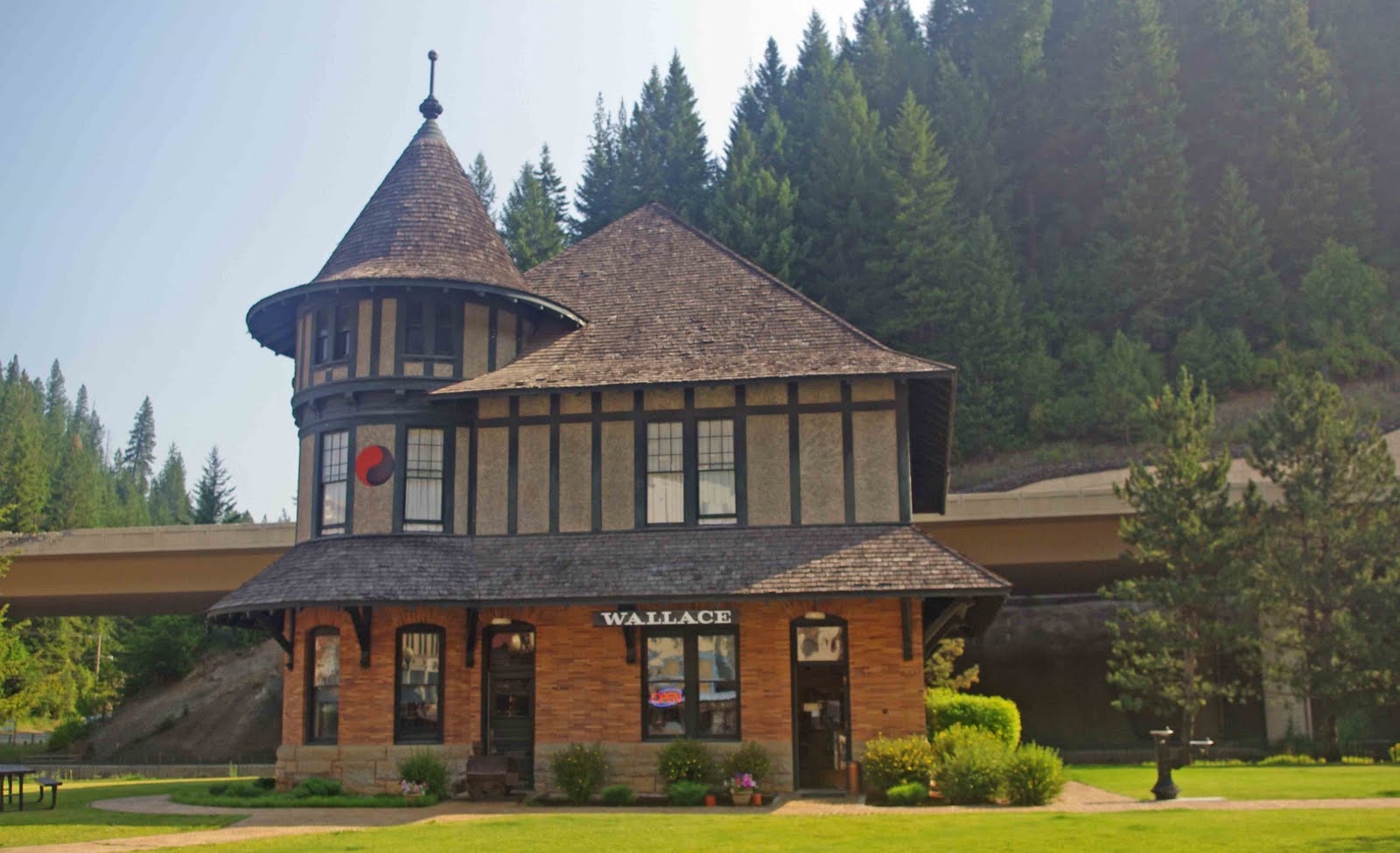
Backroads Destination-Wallace, Idaho

If and when some scientist announces that the end of world is upon us I am moving to the Silver Valley in Idaho.  The Silver Valley has survived the 1910 fire, the depression of the 30's, the Interstate Highway system, and the drop in the precious metals market in the early 1980's.  Each time it was the end of the Silver Valley and each time the community has bounced back better than before.  So when that announcement is made I am heading for the Silver Valley since I KNOW that they will survive.

Wallace was founded as a mining town and for nearly a century it survived on mining.  Now it has blossomed into a tourist town, while still maintaining their historical focus.  It is a REAL town, with real people.  If you are into mountain and road biking, ATV's, motorcycles and dirt bikes, hiking, downhill and cross-country skiing, camping, fishing, exploring the backcountry historic sites and snowmobiling the Silver Valley is calling you.


In 1972 I was working as a summer employee on the Clearwater National Forest and was driving to Spokane for the weekend.  There at the only stoplight on I-90 between Boston and Seattle I watched a young woman jiggle through the crosswalk in front of me.  Now I was a Forestry student at Berkeley in 1972, jiggling was rather common there as all the bra's seemed to have been burned.   I was surprised to experience it in conservative Idaho until a friend pointed out that she was a working girl.  I guess the Silver Valley was always into recreation in one form or another.

Well, the working girls are gone, but there is a museum dedicated to them and their history in the Silver Valley.  It is worth a visit if you were ever curious about these houses.  The FBI finally closed the last house in the Silver Valley in 1988.  Seems that they finally decided to cut the local police authorities out of bust and they did catch the girls by surprise.  The folks that purchased the building left it just as it was the day of the bust.  And after a few years started giving tours and it soon became a museum.  If you go up the road to the Murray cemetery you can visit some of the more famous ladies that lived in the Silver Valley.

The Silver Valley faced many threats to its very existence starting with the 1910 fires.  The epicenter of the fires was Wallace.  See our previous blog entries on the fire: Big Burn .  For more information read Egan's book on the 1910 fire and the Silver Valley.


Later in its history the Wallace faced destruction at the hand of the US Department of Transportation.  It seems that stoplight in 1972 really bothered the folks in Washington, D.C.  Well, it was either the town or the interstate highway system.  It ended up a draw, but the town managed to keep the impact of the interstate down to a manageable level.  Now it just appears to threaten the town, before it curves and heads just north of town.


In early 1980's the minerals market collapsed and the Silver Valley was plunged into a deep depression.  The local car dealer was on the verge of going out of business when he decided to sell cars mail order.  I was in the market for a new truck so I called him on the phone.  Now I have always had a fond place in my heart for the Silver Valley so it was easy to buy that truck from the dealer.  Even though I had never bought a truck over the phone!!  Six weeks later I went to pick up my truck in the small town of Kellogg.  Two salesman in a small building and my truck sitting out front.  Well, I guess selling trucks by phone turned out to be much, more popular than anybody imagined.  Here is a photo of ONE of their lots for trucks today.


Like I said earlier somehow the Silver Valley will survive.  But it was just not the business community.  The town of Kellogg voted to tax themselves to get matching funds from the Federal government to build a gondola from downtown to their ski hill.  They did rename the ski hill from Jackass to Silver Mountain to get the tourists to stop.  Here is the photo of the gondola, condo's and restaurants on-site.  The gondola runs on weekends during the summer and is worth a trip up the mountain.  There are also concerts up on the mountain during the summer.  It reminds me of Telluride without Oprah.

This story really sums up the attitude of folks in the Silver Valley.  I was working for BLM out of Coeur d'Alene and we did manage lots of the federal land in the Silver Valley.  One winter we had a rain on snow event in North Idaho and Shoshone County and the Silver Valley got hit really hard with flooding.  The day the rains stopped I received a call at my desk.  It was Shoshone County public works asking "Does BLM have land in the Shoshone County?"  "Yes", I answered.  Their next question was "Do you have a grader and operator?"  The answer was "Yes".  He was done asking questions.  "Send the grader and operator to the county shop tomorrow, we will be dispatching all heavy equipment in the county and fixing the flood damage."  Three days later our grader and operator returned to Coeur d'Alene.  No paperwork, no FEMA, just every piece of heavy equipment fixing the damage.  Then everybody went home.

So when that scientist says the world is ending head for the Silver Valley.  Somehow they will survive the end of the world.  Bet on it.

Remember the previous post on landforms?  Landforms and Boondocking   Well, Wallace is in a bad location for boondocking.  There is barely room for a town!  Outside of town toward Murray and Thompson Pass there are boondocking location on National Forest land.  Before climbing up Lookout Pass on the Lolo National Forest are boondocking locations.  This area is worth staying particularly if you bicycle.

Everybody traveling I-90 through western Montana and Idaho should bike the Hiawatha Trail.  It is managed under a special use permit from the Forest Service.  I have not bicycled it, but did drive it in a Forest Service truck while I was still working.  See it was work, I had to visit it in my truck!!  Great trip and there is a shuttle to get you back to the starting point!  The only downside is the trail fee.  Here is the link:  Route of the Hiawatha.

If a 17 mile mountain bike trip is a bit short how about 72 miles of paved trail?  The trail of the Trail of the Coeur d'Alenes.  Here is another web site:  Coeur d'Alenes Bicycle Trail.   This trail goes through the Silver Valley before heading into the Lower Coeur d'Alene River Valley.  If you ever wanted to complete a century ride (100 miles) this is probably the place to do it.

Soon we will cover the North Fork of the Coeur d'Alene River and the Lower Coeur d'Alene River Area just outside the Silver Valley.  Also just south of the Silver Valley is that St. Joe Wild and Scenic River.  I wrote the management plan for the St. Joe in 1979.  All these areas are worth exploring and I will cover them in future posts.

The Silver Valley is one of those special towns in America well worth the stop if you are traveling I-90.

Friday, August 6, 2010

Under Garments for BackRoads

Backroads Product-Under Garments

As a forester, bird hunter, and fly fisherman, one thing I am picky about is outdoor clothes.  That means my closet is very short on sport coats, ties, and other generally useless clothes. But when it comes to preparing for outdoor activities, I am always well-dressed and comfortable.

So, lets start with the basics.   I hesitate to call these items underwear, since they're function is to keep you warm and dry before all else.  I am also big into natural fibers, simply because you know what your getting; whereas, with man-made fibers it seems they just keep changing.

Silk is great for cool, rather than cold, weather.  I wear silk t-shirts with long sleeves and silk long john bottoms.  I wear them fly fishing in my float tube during the warmer months.  Black is the color of choice for the outdoors. 

By accident, I discovered a handy use for them as pajamas.  Normally, I do not wear pajamas because when I toss and turn they bind and I wake up.  However, it was a dark, stormy cold night during a bird hunting trip and my sleeping bag was just not warm enough.  So I reached in and grabbed the silk.  Much warmer, and they slipped nicely when I tossed and turned without waking me up.

For those women that like to sleep in flannel nightgowns, try a set of silk undergarments.  The somewhat see through characteristic will improve the scenery significantly over the flannel nightgowns, and both of you will sleep better.

In colder weather, I move up to Merino wool.  These are warmer than silk, do not itch, and stay warm when wet.  They also do not have the odor that normal wool has when it is wet.  I have several sets of these since I tend to hunt and fish in fairly cold weather.  Most folks will probably just need one set, for those really chilly times when the jet stream dips far to the south in winter.

For both the Merino wool and silk, underwear bottoms are also available.  They are also available in different colors and with short-sleeves and turtlenecks options.  There are plenty of styles to choose from.  For me, it is long sleeves for the cold and black so the dirt does not show!

For socks I finally pitched ALL my socks except for the Costco Kirkland Outdoor Trail Sock.  They come in a four pack and are a Merino Wool Blend.  It does not appear Amazon offers the four pack, however, they do offer lots of Merino socks that should work just as well.  I used to wear a liner sock to prevent blisters in the past, but with these Merino socks the liners are just not needed.

My only complaint about the socks is they come in four slightly different colors so you have to sort socks.  I'd just as soon have them all the same color so I can just toss them in the drawer without sorting.  Life is too short to mess with small stuff. 

So now we have the basics covered.  Next I will cover "covering the basics".

Going to where the climate suits my clothes...

Wednesday, August 4, 2010

What's in a Name?


This is how the Blue Mountains in north-east Oregon got their name.


Backroads Information-Place Names

One of the great disappointments of the late 20th Century is that place names have become decoupled from reality.  Subdivisions are called Fox Run, Quail Hollow, and Poppy Lane but their names have nothing to do with reality, except as a marketing gimmick.


However, this was not always true.  During the settlement of the west names did have meaning.  Many places were named after early settlers so the place name was also the mailing address.  However, up on the National Forests and BLM lands the names became more descriptive.  Some creeks were named after the nationality of the squatters that lived there with many of these being "cleaned up" in recent years.

Some were named after businesses that were operated on site.  So WhoreHouse Meadows was an advertisment as well as a place name.  Unfortunately, in Oregon BLM has now renamed WhoreHouse Meadows to Naughty Girl Meadows.  Visitors today have no clue what the naughty girls did at that meadow!   Maybe, they rode their mountain bikes in the meadow?  Perhaps they played their radio's too loud.  A part of history ceased to exist with the renaming.

On BLM lands in Idaho you can still find Two-Bit Creek and one ridge over Floozy Creek.   Those naughty girls did get around!

So what does this have to do with exploring the public lands.  Plenty.  Use the names as a descriptive guide as well as a location.

For example, Fish Lake.  Fish Lake is a very common name throughout the west.   In my travels, throughout the west I have always found it worthwhile to fish lakes named Fish Lake.  The early settlers were not to concerned about people finding out their secret fishing spots.  Any guess as to the fish species your going to catch at Cutthroat Lake?   Beaver Lakes are worth fishing since it indicates shallow, more productive lakes.


If this is named Duck Pond, where are the ducks?

Other common names for lakes in the west are Gold and Silver Lakes.  It has been my observation that Gold Lakes tend to be more scenic than Silver Lakes which come in second .  So if it is scenery your looking for go to Gold Lake first.  The names probably came from the relative worth of gold and silver in the late 1900th century.  It did not come from the summer Olympics since there are very few Bronze lakes to be found.

You will find a Surprise Lake when you least expect it.  I would keep a clean camp at Bear Lake.  There will be a rocky shoreline around part of Talus Lake.  You will probably have a hard time finding Hidden Lake.  There will be a yellowjacket nest around BeeHive Lake.  Careful around Moose Lake they can be rather cranky.  I would not camp at Gnat, Mosquito, or Mud Lake.  Rainbow Lakes are usually good fishing.   Twin Lakes always come in pairs, so if you do not like one go to the other.

If you like looking for old stuff anyplace with diggins as part of its name should have lots of old mining equipment laying around.  I would not camp in early season in any place named Mosquito Flat, though in the fall it might be a great spot.  Anything with HooDoo or Dalles will have some nice rock formations.

Save hiking for Rattlesnake Creek for the colder months of the year.  

We have a house on Camas Meadows.  The most common wildflower on the meadow is Camas and the meadow turns into a sea of blue in the spring.  Be sure to visit these special spots at the right time of year.

Now sometimes you can get fooled.  Back in the turn of the  20th century the Early Winters Ranger District named a trail with a tricky stream crossing and 4000 feet of straight up elevation gain in less than four miles the Easy Pass Trail.   When  the new summer employees would show up they would be sent on an hike on the Easy Pass Trail first thing.  Some of those folks would quit right then and there, thinking "If that the EASY Pass trail, what do the other trails look like!".

Of course, turnabout is fair play particularly after a 100 years.  I intend to show up at the Ranger Station wearing flip-flops and a couple of grand-kids in tow.  And tell them that for a first hike the Easy Pass Trail was fantastic and do you have any trails where we could get some exercise?

So break out those Forest Service, BLM, or topographic maps and start thinking about those names.  You can find some special spots just by paying attention to the place name.


Elk City, Idaho??

Monday, August 2, 2010

Sierra Buttes, Sierra City, California

 Backroad Destination:  Sierra Buttes, California

We are running behind on visiting new areas.  So I am bringing to you places that I have visited in the past.   In many cases, I do not have photographs to post so bear with me.  However, these spots are just as special now as they were in the past.  You will have a little less information prior to exploring these spots.  

At the northern end of Highway 49 is a pot of gold known as Sierra Buttes.  This was one of my favorite spots in the Sierra's when I lived in California during the 1970's.  It has been well over 35 years since I have been at Sierra Buttes.  I am sure that the mountains are still as beautiful as they were 35 years ago.  I am sure that there are more people now than then.  The Buttes are still worth the visit.  So go and see for yourself and comment here on the blog on what I missed the last 35 years.

To bring up this map do a Google Earth search on Sierra Buttes, California.


As you can see from the Google Earth image there are lots of lakes, lots of photo points, and lots of trails to explore.  When I was there the fishing was outstanding.  I camped at Lower Salmon lake, driving my little red two-wheel Datsun pickup down the road.  On the way out I noticed a sign stating 4-wd only.  I do remember parts of that road.  Not sure I would drive it again with a 2 wheel drive vehicle!  Wisdom of age?

For such a pretty area information on the web is hard to find.  There are Forest Service campgrounds with prices at $17 to $21 a night without discount passes.  Spurs are all in the 30 foot range so if you are long it might be difficult to find a spot.

Sierra Buttes is a great place for short day hikes or overnights.  If you are interested in trying backpacking this is a good area for a first trip.  Here is the link for trails in the area:  Sierra Butte Trails.  Zoom in on the map for a better view of the trails.

There are lots of lodges and "rustic resorts" in the area so you can get supplies or dinner.  We have no recommendations since it has been 35 years!  It is 1500 miles from our house to Sierra Buttes.  We will get there next or soon thereafter.

If your in California drive up Highway 49 and take the turn north to Sierra Buttes.  See if you can find your "pot of gold".   Be sure to post your comments on this blog.