Friday, March 22, 2013

Alamo, Nevada to Boise, Idaho--Running Against the Wind


Alamo, Nevada to Boise, Idaho--Running Against the Wind.

We left sunny, warm Alamo and started heading north and right away started running into cool  weather and wind.  Is the picture above showing high winds aloft?  The wind slowed our speed down to 45 to 50 MPH for stretches at a time.  We did notice this sign just outside of Alamo and given the design of the aircraft I suspect it might be a bit more stable in high winds than the box that is our 5th wheel.


There is a rest area right at the junction of Hwy 318 and Hwy 375.  Given its location relative to roads it might catch every headlight all night long!


There is a state of Nevada wildlife area adjacent to the rest area, but it appears that camping is not allowed there.  Here is the link to information on the area:  http://ndow.org/about/pubs/wma/wma_pittman.pdf.

We fought the headwind all the way to Ely, Nevada.  It was only about 140 miles but seemed much longer than that!!  We opted not to boondock this time at the Sinclair gas station.  So we stayed at the Prospector Hotel and RV Park.  It was $15 a night for full hookups and wireless internet.  Great breakfast in the hotel.  Entry and existing was somewhat tricky.  I would enter south of the hotel, go around the back and down into the RV Park and the six pull-throughs.  I exited by heading north right in front of the hotel.  That Texaco station across the street was the last gas for many miles!!


Heading north on 93 we ran into Bugaboo's old friend the Pony Express rider.  However, Bugaboo remembered that he did not play with him two years ago so and ignored him.  Snowpatch, on the other hand, thought that the Pony Express rider was a friend of that "Giant Quail" in Gila Bend and refused to even come close.  Here is 2010 posting on the route to Jackpot.  Notice that the rest area has been rebuilt.


We continued north in high winds until finally reaching Jackpot.  The review is here.  The water was still off at the campground and was not scheduled to be turned on until May.  So get your tank filled before setting up. The lower campground does has drinking water that can be used to fill your tanks.

After Jackpot we decided to head to Boise.  We took Highway 20 through Buhl and that was a great route hitting I-84 west of Twin Falls.

We braved the traffic and landed at Riverside RV Park in Boise.


Sunday, March 17, 2013

Alamo, Nevada


usbackroads destination-Alamo, Nevada.

We pulled out of Bullhead City heading north, but first headed west to hook-up with I-15 and hopefully stay on it through Las Vegas.  An adventure, taking the routes through Las Vegas when your 49 feet long.

We finally felt like we were headed home after turning onto 93 north!  There is so much to love about Nevada.  The wide open spaces and bankrupt developments or maybe just on the edge.  They do know how to spend money on an entrance!!


For Bugaboo, the attraction is he can wander the highways without worrying about cars.  However, when I first drove this highway from Las Vegas to Twin Falls in 1978 I believe I saw two cars!  It was a lot more crowded today.  Had to keep an eye on Bugaboo.


I am a sucker for small towns.  Alamo is actually a fairly large town for Nevada, with a small grocery store.  A great Sinclair gas station with diesel and great access for truck and trailer.   There is a Mexican restaurant named Carlos that was suppose to be good, but we passed and instead went to "the Scoop".  This was an real ice cream place with real ice cream.  Great stop and a very short walk from the RV park.

I tried to ride the bicycle up to the hot springs five miles north of town on Highway 93, but decided that was a bad deal as there was no shoulder and the speed limit is 70 mph.


So I decided to stop at the local cemetery to pay my respects to the departed.  Lots of men in their twenties decided to check out of the earth.   There was one gentleman that was an Oakland Raider fan to the very end.  He was probably not very happy with the last decade of Raider football.

However, as always the cowboys show style even in death.


I turned around and headed backed to town and cruised the roads of Alamo.  Alamo might be a little town, but it is much bigger than many places I have lived.

The RV Park had the basic essential services.  The high point was the campground wi-fi system.  It actually ran at 3mbps!!  This is the fastest internet since we left Oregon is mid-November.  We should be back in Wenatchee and our standard 100mbps service in a week.  I am so ready.

Alamo serves as the base for exploring the BLM lands just outside of town.  We ran into a Canadian couple that have extended their stay from one day to four to explore Lincoln County.  Here is the link to the on-line resources of the county:  Lincoln County Travel Center Links.

Just south of town is the wildlife refuge that we mentioned in 2010:  Places to Camp....Las Vegas to Ely.

Next posting is on the hot springs in the area.


Wednesday, March 13, 2013

Augie's Quail Trail RV Park, Gila Bend, Arizona


usbackroad-Augie's Quail Trail RV Park, Gila Bend, Arizona.

Back on the road again and headed home.  We got up in Benson, Arizona and turned up the furnace.  A little less than 200 miles later we are in Gila Bend, Arizona and running the air conditioner all day and probably most of the night.  However, Gila Bend was well within our 4 hours and 200 miles of driving per day.  And who would not want to stop in a spot with such a cool name as Gila Bend.

Our choices were the RV park at the Shell Station and Augie's.   The Shell Station had good reviews:  Holt Shell Station Review by We Call it HOME.


The reviews Augie's were notas promising.  Basically really nice folks running a park with issues!  Well, the reviews are basically correct.

For $30 a night you get water, electric, and a sewer hook-up.  No cable TV and they do advertise Wi-Fi throughout the park, but I was never able to make a connection on the three computers we have with us.
For an overnight stay you are better off boondocking than paying $30 for hookups that you really don't need.

But as the reviews noted the managers are real nice.  I hope the owner pays them a good wage since it is probably the only thing keeping the park open.  Most of the park is occupied by construction workers in the area.  So spots were limited AND the RV park at the Shell Station was fully booked.

There is over the air TV with a grand total of TWO.  One is English, and one in Spanish.  The English station broadcast Judge Judy and all her legal friends, while the Spanish station had some pretty hot video's and TV shows.  I am very curious about the Mexican fascination with blondes.  Not many natural blondes in Mexico, but they are all over Mexican TV broadcasts.  AND why are Mexican stations broadcasting in the US NOT required to have closed-captions??  Some of that stuff sounded real interesting but I really NEEDED CLOSED CAPTIONS IN ENGLISH.  Where is the FCC when you really need them!!!

I picked out a campsite with a really cool sculpture of a quail.


Bugaboo just ignored the bird.  However, Snowpatch the dog that chases quail and pheasants was suddenly faced with an apparition of a quail 20 times his size.  His reaction....well just look at that tail.


And the first chance he gets.....he is off and running in the opposite direction!!  Notice the tail.


We are following Comet PanStarrs.  Here is the link to the Sky and Telescope web site:  Comet PanSTARRS.  As Sky and Telescope says "It's certainly not the spectacle we once hoped for — but it's there, and it's becoming less difficult each evening."  It is bright and easily visible in binoculars.  So look to the west in the twilight with your binoculars and see one of natures spectacles.   There might be a much brighter comet next fall, but this one is pretty nice.  If you have a friend with a telescope it looks even better.

The road continues north tomorrow.  


AND final shot of the RV park.  The Verizon tower is in the park so phone and data services are pretty good in the park.  They did slow down in the evening when everybody fired up their Verizon modems.


Friday, March 8, 2013

Boquillas Ranch Trails, San Pedro Riparian National Conservation Area, BLM, St. David, Arizona


usbackroads destination--Boquillas Ranch Trails, San Pedro Riparian National Conservation Area, BLM, St. David, Arizona.

In 2010, we visited this area, but explored the Fairbank Historic Townsite.  You can view the posting by click on this link:  Fairbank Historic Townsite.  This trip we focused on the trails that are in the area.  From Highway 82 there are trailheads on both sides of the road.

The northern trailhead is a single track trail going north past Fairbank Cemetery, and the Grand Central Mill site.   Where the trail reaches the San Pedro River it loops back to the Fairbank townsite.  The entire trail is about three or four miles in length.  We did it on our bicycles, before we got Snowpatch's panniers.

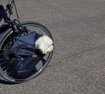
He does look a little skeptical about the entire backpack thing.

The first half of the trail (eastern half away from the river) has only a few sandy spots and is fairly easy to bicycle.  After the turnaround point the trail has some substantial sandy spots that are difficult to bicycle.  The score for the entire trip was SAND 4, SUSIE 0.  Since she was behind me I did not get to witness the dismounts.  Some were rather impressive according to her.

Snowpatch and I stayed upright.

This is a good walking trail.  I probably would not bicycle the riverside part of the trail due to sand, but it would be a wonderful loop walk.

The southern trailhead leads to the Boquillas Ranch which is now owned by BLM.  This is a gated road.  Some washboards, a couple of sandy washes, but a much better trail to bicycle.


The original ranch property is still pretty much intact.  There is a cool barn, a couple of houses, workshops, water tank, and all the other necessary ranch goodies.


For Bugaboo and Snowpatch the real attraction was the San Pedro River.  Bugaboo looks good wading the river, Snowpatch on the other hand appeared to be a drowned white laboratory rat.  A couple of hawks watched him with intense interest, but then decided to move on.


Snowpatch did enjoy his new mode of transportation.  We did the north half with Snowpatch in a backpack and the south half with his new shiny panniers.  He seemed comfortable with the panniers, since it was them or the kennel in the truck.


The ranch is a good spot for a picnic lunch.  You can follow a faint trail to the west to reach the river.  It is possible to bicycle from Charlestown all the way to the trailhead.  However, a bicyclist reported that the trail was "rather technical" in some spots and there were some sandy washes that also had to be crossed.  He was complaining, but his girlfriend that was running the entire route said little.  I suspect they were military from Sierra Vista and being in their twenties that fact convinced me to stop at the ranch and leave Charleston for another day.


I am not sure what BLM's plans are for the area.  I could not find a management plan on-line for the Conservation Area.  The ranch would make a dandy environmental learning center.  AND since a campground is NEEDED inside the Conservation Area, the ranch with its water supply and facilities would make a dandy spot.  The road can remain gated and closed except campers and others staying at the environmental learning center.

The San Pedro Riparian National Conservation Area is a special spot.  We are still exploring new areas on our second year in the area.  Great spot, close to Benson, Sierra Vista, St. David, Tombstone and other communities....which really should be linked to the Conservation area with bicycle trails.  Oh, I am starting to think like I am still working.  Have to leave that for the other folks!

Sunday, March 3, 2013

Hot Well Dunes, Safford, Arizona


usbackroads destination--Hot Well Dunes, Safford, Arizona

Two years ago, we called BLM for instructions on how to find this recreation site.  We were informed that the "Hot Wells" were no longer artisian and that the BLM was looking for funding to "fix" the wells and recreation facilities.

The original "hot wells" came from oil and gas drilling way back in the 1920's.  Instead of oil, they hit hot water and these became the "hot wells".   Another benefit of America's oil and gas industry!!  The dunes over the years became popular with the ORV crowd and I am sure that between the "hot wells" and ORV party crowd it must have been quite a spot over the years.

BLM did find the funding from Arizona's ORV fund and I suspect some government funding.  But I suspect the ORV crowd funded most of the reconstruction of the recreation facility and "hot wells".


The site is split into basically four areas.  The first is a day use picnic site with a natural hot water pond.  The second is the "rustic" campground.  The third are the "hot wells".  And at the end of the road is the ORV parking.

The picnic area is the quiet and far from the ORV area.  It is worth a stop.  The fee for using the recreation facilities is $3 per day.  So if you are camping area it is a $6 per night fee.  Half-price discount for federal access and senior passes.

For this you might get a picnic table, parking area, garbage can, restroom and access to the "hot wells".

Quite the bargain for $3.  As always, click on photo to enlarge.


Signs, signs everywhere a sign.  These at least have some information on them.  Here is the sign at the picnic area.  For some reason I never did get a good picture of the area, however, click on the sign for the basic information.


These are the campsites.  As you can see the campground is rustic and fairly undeveloped.  Well in keeping with BLM's low key approach to recreation.  What more do you need??  I like these type of campgrounds in the right setting.


Well, the campground was an easy "recreation planning" problem.  The "hot wells" were more difficult.  How do you design a hot springs to be rustic, safe, durable, and cheap to maintain.  Here are the pictures.  What do you think??

This is the picnic area and parking lot at the "hot wells".


This is the toilet facility.


This is the solar pump house to keep the "hot wells' flowing.  Well, I probably would have mated the toilet with this building to minimize the number of structures.


And here are the "hot well tubs"!!


The sign on dogs was a little unclear.  We first thought, it meant no dogs inside the fence portion of the tub, however, on later reflection I think BLM meant keep dogs in the parking area.

The hot tubs are 106 degrees F.  and quite comfortable.  There is a very faint sulfer smell and little bits of algae floating around.  However, quite nice for a hot springs out in the wilds.  Don't let the cement and fence fool you.....this is no motel pool hot tub.  I suspect I would worked a bit harder for a more rustic design for the simple reason I would not want to answer the letters about "unclean" etc. etc.

Just to be sure you do mistake these for hotel hot tubs there is this sign.

Now a simple little Honda 2000 generator would let those tubs fill in darkness!!  All BLM would need to do is provide a plug to the Honda generator.

Then it dawned on me that ORV's, hot tubs, alcohol,  and hot desert nights probably lead to some interesting activities which I am sure that BLM has NO INTEREST in seeing happen on Federal land.


So...hey no sun.  No hot water for people to sit in and get wasted.  Clever, very clever. IF I was still working I would do the same thing in a heartbeat.

Finding the Hot Wells Dunes is best done from Bowie rather than Highway 191.  You could tow anything in from the Bowie side.  The 191 approach is fine, but narrower and with less reassurance signing.   One warning.   We came in from Highway 191 and left via Bowie.  But our GPS unit wanted to send us off on some interesting roads on the desert floor.

Stick to the main route.  From Bowie you will go through paved and unpaved, but very wide road that makes sharp turns through pecan orchards.  Guess they just followed property lines!

When you hit the BLM managed lands.  The road narrows, but is covered with chip seal.


BLM rules regarding dogs are under voice control or on a leash.  Bugaboo, all 100 lbs of him, is fine with voice control.  Snowpatch, all 12 lbs of him, has never even considered the concept.  So here he is in the middle of somewhere on a leash.  Oh yes, he did run off at Hot Wells Dunes to chase quail.   I guess he does not believe bird season is over.  The picture gives you an idea about road quality.  I suspect the road is like this all the way to Safford.  It might be interesting to ride the road on a bicycle.  Little traffic.

This is what the land looks like in the area.  BLM Big Sky Arizona.


We did see this sign just west of the Hot Wells Dunes.  Not sure what it means, but if you area interested in dispersed camping near the Dunes you might want to call BLM.  We did see people in hunting camps several miles north and west of the area.  Click on picture to enlarge.


Here is the link to the BLM office in Safford:  Safford Field Office Web Page.